Fuji

 |
| Yoshihara Gion Festival in Fuji |
Fujieda
Fujieda is primarily a bedroom community for nearby Shizuoka. The local economy is dominated by agriculture (tea, strawberry, rice, shiitake) and by light manufacturing, including pharmaceuticals, beverages, and food processing. In the Edo period, much of the area of present-day Fujieda was part of Tanaka Domain, and its castleformed part of the eastern outlying fortifications of Sunpu. The town also developed as Fujieda-juku, a post town on the Tōkaidō highway connecting Edo with Kyoto.
Fukui
 |
| From top left: Ichijōdani Asakura Family Historic Ruins, Kitanosho Castle, Fukui Castle and Fukui Prefectural Government, Cherry trees along theAsuwa River, Echizen-Kaga Kaigan Quasi-National Park |
As of November 1, 2009, the city has an estimated population of 267,428 and a density of 499 persons per km². The total area is 536.17 km². Most of the population lives in a small central area; the city limits include rural plains, mountainous areas, and suburban sprawl along the Route 8 by-pass. Fukui was devastated by Allied bombing in 1945. American heavy bombers leveled some 86% of the city during the United States sustained strategic carpet-bombing campaign against the Empire of Japan. Fukui was again devastated by a major earthquake in 1948. The city has regained its energy and vitality. Hence, the city's official symbol—the phoenix.
Fukuroi
Fukuroi has a mixed economy of agriculture and light industry. The principal crops are green tea andmelons. Industry includes food processing, cosmetics, pharmaceutical plants, as well as electronics and automotive components. Fukuroi is on the coastal plain in southwestern Shizuoka Prefecture. It is bordered by the Pacific Ocean to the south. The area has a mild maritime climate with hot, humid summers, and short, cool winters.
Fukutoku
Gifu
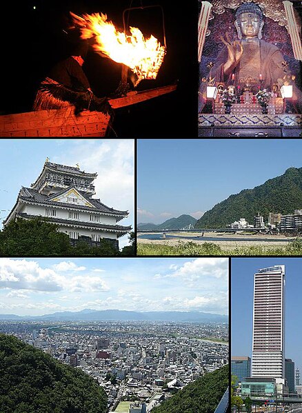 |
| Top left: Cormorant fishing in Nagara River, Top right: Gifu Great Buddha Statue, Middle left: Gifu Castle, Middle right: View of Nagara River and Mount Kinka, Bottom left: View of downtown Gifu from Mount Kinka panorama road, Bottom right: Gifu City Tower 43 |
Located on the alluvial plain of the Nagara River, Gifu has taken advantage of the surrounding natural resources to create both traditional industries[5] (including Mino washi and agriculture) and tourism opportunities like cormorant fishing.[6] Mount Kinka, one of the city's major symbols, is home to a nationally-designated forest and Gifu Castle, a replica of Nobunaga's former castle. Gifu also hosts many festivals and events throughout the year.
Gokiso
Hamamatsu
Hamamatsu (浜松市 Hamamatsu-shi) is a city located in western Shizuoka Prefecture, Japan. On July 1, 2005, the city merged with 11 surrounding cities and towns. It became a city designated by government ordinance on April 1, 2007. The area now comprising Hamamatsu has been settled since prehistoric times, with numerous remains from the Jomon period and Kofun period having been discovered within the present city limits, including the Shijimizuka siteshell mound and the Akamonue Kofun ancient tomb. In the Nara period, it became the capital of Tōtōmi Province. During the Sengoku period,Hamamatsu Castle was the home of future Shogun Tokugawa Ieyasu. Hamamatsu flourished during the Edo period under a succession of daimyorulers as a castle town, and as a post town on the Tōkaidō. After the Meiji Restoration, Hamamatsu became a short-lived prefecture from 1871–1876, after which it was united with Shizuoka Prefecture.
 |
| From top left:Act City Hamamatsu, Akihasan Hongū Akiha Jinja, Enshu Railway Line, Hamamatsu Castle, Hamana Ōhasi |
Ichinomiya
Ichinomiya (一宮市 Ichinomiya-shi) is a city in Aichi Prefecture, Japan. The city is often called Owari-Ichinomiya to avoid confusion with another Ichinomiya (now part of the city of Toyokawa). The pre-expansion city was once part of now-defunct Nakashima District until September 1, 1921. Ichinomiya literally means "the first shrine" of the province. In case of this city, it was Masumida Shrine of Owari Province.
Ichinomiya (一宮市 Ichinomiya-shi) is a city in Aichi Prefecture, Japan. The city is often called Owari-Ichinomiya to avoid confusion with another Ichinomiya (now part of the city of Toyokawa). The pre-expansion city was once part of now-defunct Nakashima District until September 1, 1921. Ichinomiya literally means "the first shrine" of the province. In case of this city, it was Masumida Shrine of Owari Province.
 |
| Masumida Shrine in Ichinomiya |
Ina
The city was founded on March 31, 2006 when the old city of Ina merged with the town of Takatō and the village of Hase, both from Kamiina District, to form the new city of Ina.

Inuyama
In October 1, 1889, the town of Inuyama was created. Inuyama was elevated to city status in 1954. The most famous attraction is Inuyama Castle on a 40-meter rise overlooking the Kiso River. ThisJapanese castle was designated as a Japanese national treasure in 1935 and again in 1952. The castle in its current form was built in 1537 by Oda Nobuyasu, grandfather of the great warlord Oda Nobunaga. The castle is the only privately owned castle in Japan, and has remained unchanged since it was built, making it the oldest original wooden castle in Japan.
 |
| Inuyama Castle |
Ise
Ise, formerly called Ujiyamada, is a city located in eastern Mie Prefecture, on the island of Honshū, Japan. Ise is home to Ise Grand Shrine, the most sacred Shintō Shrine in Japan, and is thus a very popular destination for tourists. The city has a long-standing title — Shinto — that roughly means "The Holy City" and literally means "Capital of the Kami". Most of the city is within the geographic limits of Ise-Shima National Park. Ise's history is directly linked to that of Ise Grand Shrine. Ise Grand Shrine is separated into two main parts: The Inner Shrine and the Outer Shrine. Despite the names, these are actually two physically separate shrines approximately six kilometers apart. Among over 80,000 shrines throughout Japan, the Ise-jingu Shrine is said to be the most historical and venerable shrine. The Japanese people have lived in accordance with nature and the current site of the Ise-jingu was worshiped without any buildings in the earliest times, due to its deep forests of sacred Japanese cypress trees. It has been favored for thousands of years, popularly known as “O-Ise san,” or “Daijingu san.”
Kanazawa
Kanazawa sits on the Sea of Japan, bordered by theJapanese Alps, Hakusan National Park and Noto Peninsula National Park. The city sits between theSai and Asano rivers. Its total area is 467.77 km². Kenrokuen Garden is by far the most famous part of Kanazawa. Originally built as the outer garden of Kanazawacastle, it was opened to the public in 1875. It is considered one of the "three most beautiful gardens in Japan" and is filled with a variety of trees, ponds, waterfalls and flowers stretching over 25 acres (100,000 m²). In winter, the park is notable for its yukitsuri – ropes attached in a conical array to trees to support the branches under the weight of the heavy wet snow, thereby protecting the trees from damage.
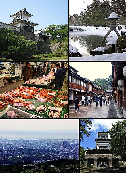 |
| From top left: Gate of Kanazawa Castle, Kenroku-en, Ōmichō Market, Higashi Geisha District, Kanazawa seen from Mt. Kigo, Oyama Shrine |
Kariya
Kariya is a city located in central Aichi Prefecture, Japan. As of October 2011, the city had an estimated population of 145,955 and a population density of 2890 persons per km². The total area was 50.45 km². The economy of Kariya is dominated by companies related to Toyota Motor Corporation, including Toyota Industries Corporation, Aisin Seiki and Denso Corporation. Toyoda Automatic Loom Works, Toyodajidoshoki, was the original company of Toyota Motor Corporation, and later became a subsidiary of that firm. Because the Toyoda Automatic Loom Works was so highly profitable, board members decided to reinvest much of the profits into the growing automobile manufacturing business.
 |
| Kariya city Hall |
Kasugai Kasugai is a city in Aichi Prefecture, Japan. As of February 2012, the city has an estimated population of 306,573 and a population density of 3310 persons per km². The total area is 92.71 km². Former Nagoya Airport, is located between Kasugai and neighboring Komaki. During the Meiji period, the area was organized into villages under Higashikasugai District, Aichi, with the town of Kachigawa established on July 25, 1900. On June 1, 1943, Kachigawa merged with neighboring villages of Toriimatsu and Shinogi to form the city of Kasugai. In 1958, Kasugai annexed the neighboring towns of Sakashita and Kozoji. Kasugai gained Special city status on April 1, 2001.
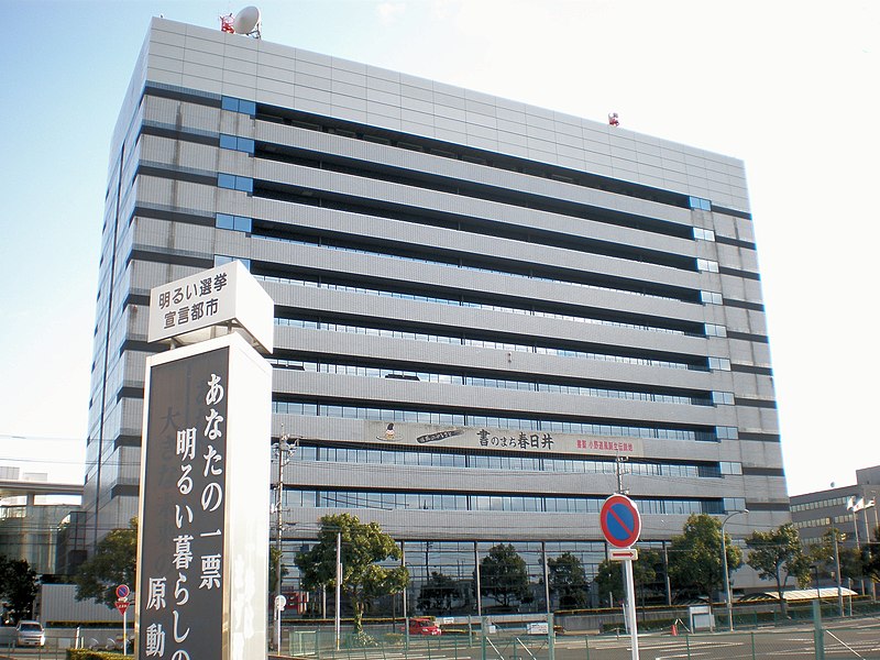 |
| Kasugai City Hall |
Komatsu As of 2008, the city has an estimated population of 109,285 with a density of 294 persons per km². The total area is 371.13 km². The modern city was founded on December 1, 1940, although its history extends to feudal times. It is the third-largest city in the population in Ishikawa prefecture after Hakusan city was formed and came to the second in 2005. Interesting places in Komatsu are the Nata-Dera Buddhist temple complex, the Yunokuni-no-mori traditional handicrafts village, Hoshi Ryokan (the worlds oldest hotel), and the Motorcar Museum of Japan which is the largest museum dedicated to motor vehicles in Japan with a 12,000 square metre display area. Nearby is the well-known Kaga hot-springs district.
 |
| Old Town Komatsu |
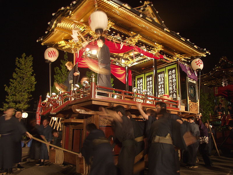 |
| Otabi Matsuri Festival |
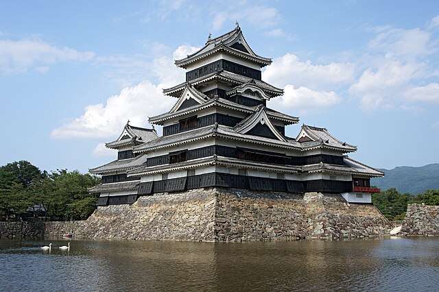
Matsumoto
Matsumoto City
is located in Nagano Prefecture on Honshu, the main island of Japan. This picturesque castle town is nestled between the Japanese Alps and Utsukushigahara Heights (meaning "beautiful plateau"). Matsumoto boasts a surprisingly metropolitan atmosphere while maintaining historical sites and traditions. The streets are clean and the people are friendly. The region is famous for delicious apples and soba (buckwheat noodles), and is the birth place of the contemporary artist Yayoi Kusuma as well as the Suzuki music method.
Every season offers a different allure to Matsumoto, which is Nagano prefecture's prettiest destination, year-round. In spring, watch cherry blossoms complement the black roof of the 400-year-old castle with a backdrop of snowy mountains. In summer, enjoy the cool breeze of a day hiking in Utsukushigahara Heights and an evening watching Seiji Ozawa conduct at the world class Saito Kinen Festival. In autumn, go apple picking or watch the leaves change while hiking through Kamikochi in the Central Mountains National Park. Then enjoy local soba at a moon viewing party at the castle. In winter, enjoy skiing at the three high altitude resorts before relaxing in one of the many fine onsens (hot springs).
Meito
Meitō-ku is one of the 16 wards of the city of Nagoya in Aichi Prefecture, Japan. As of 2011, the ward had an estimated population of 161,416 and a population density of 8,300 persons per km². The total area was 19.44 km². One of the most famous landmarks in Meito-ku is Nagoya Castle. During the Edo period, Nagoya Castle was the center of one of the most important castle towns in Japan—Nagoya-juku— and it included the most important stops along the Minoji, which linked the Tōkaidō with the Nakasendō.


Nagano Nagano, the capital city of Nagano Prefecture, is located in the northern part of the prefecture near the confluence of the Chikuma and the Sai rivers, on the main Japanese island of Honshū. Nagano is most famous for Zenkō-ji, a 7th century Buddhist temple which overlooks the city. A million tourists visit Nagano annually, the gateway to a variety of sightseeing spots. Nagano was originally a small town in Kamiminochi District built around the hilltop temple, the largest wooden building in eastern Japan, but the city now encompasses locations that were within Sarashina, Hanishina, and Kamitakai districts as well.
 |
| From top of left, Zenkoji, Mount Togakushi, Kinasa village, Nagano Big Hat arena, Airial in Kawanakajima, Oku-Subana Valley, Marukome, which headquarter in Nagano, and famous for miso product company in Japan, Oyaki Japanese sweets, Togakushi ski place, and Matsushiro Castle |
No comments:
Post a Comment