Nakatsugawa
 |
| Downtown area of Nakatsugawa |
Nakatsugawa is known for its abundant chestnut harvest and the chestnut delicacies known as kurikinton. Kurikinton are produced by first boiling and then mashing the chestnuts, then mixing them with sugar and reforming them into a chestnut shape. They are widely available during the Autumn months. Many families make their own in their own kitchens, while purchased kurikinton are extremely popular as well for home consumption and as gifts.
Nanao
The city of Nanao was founded on July 20, 1939. The name "Nanao" literally means "Seven Tails" and is said to be named for the seven mountain ridges (or "tails") surrounding Nanao that are visible when viewed from Joyama, site of the city's historical castle ruins. These ridges are called Kikuo "Chrysanthemum Tail", Kameo "Turtle Tail", Matsuo "Pine Tail", Torano'o "Tiger Tail",Takeo "Bamboo Tail", Umeo "Plum Tail", and Tatsuo "Dragon Tail".
Nonami
Part of the area of what is now Nonami was the site of the Battle of Okehazama during the Sengoku period, between the forces of Oda Nobunaga and Imagawa clan. All of what is now Midori Ward was part of the holdings of Owari Domain during the Edo period. The Tōkaidō post town of Narumi-juku prospered under the Tokugawa shogunate. After the Meiji Restoration, the area was organized into villages under Aichi District or northern Chita District within Aichi Prefecture. Narumi became a town in 1889, followed by Arimatsu in 1890 and Otaka in 1895. Efforts to merge these towns with the neighboring city of Nagoya began in 1953 and 1955, but were virulently opposed by the local residents, resulting recall motions for town mayors, and eventually violent riots. On April 1, 1963, after a third referendum, Narumi was annexed by Nagoya, becoming the new ward of Midori. Narumi was followed by Otaka and a portion of Arimatsu on December 1, 1964 with each of the former towns retaining its own local sub-ward office and considerable local autonomy.
Numazu

Numazu is at the northern end of the Izu Peninsula, which is a leisure destination known for its numeroushot springs. Mount Fuji, Japan's tallest mountain, may also be seen from Numazu on clear days. Numazu is located 130 kilometres (81 mi) west of Tokyo and is on the Tōkaidō Main Line, the main railway line from Osaka to Tokyo. Warmed by the Kuroshio Current, the area enjoys a warm maritime climate with hot, humid summers and mild, cool winters. The Kano River runs through the middle of the city. Numazu is an industrial city and regional financial center, and its port is a major center of Shizuoka prefecture's fishery industry. Numazu produces more dried horse mackerel than any other region in Japan. The city accounts for about half of Japan's total production. Agriculture is dominated by production oforanges and green tea, with Brussels sprouts, dairy products and rice as secondary products. Numazu is the location of the head office of Suruga Bank, Shizuoka Chuo Bank and Numazu Shinkin Bank.
Ogaki

Ōgaki is a city in Gifu Prefecture, Japan. It was incorporated as a city on April 1, 1918. As of 31 January 2013, the city has an estimated population of 163,364[1] and a total area of 79.75 square kilometres (30.79 sq mi). Ōgaki was the final destination for the haiku poet Matsuo Bashō. Every November the city holds a Bashō Festival.
Okazaki

Okazaki is famous for its fireworks. The Tokugawa Shogunate restricted production of gunpowder outside of the immediate region of Okazaki (with few exceptions), and even today, more than 70% of Japan's fireworks are designed and manufactured here. A large fireworks festival, which people from all over Japan come to see, is held annually on the first Saturday in August in the area surrounding Okazaki Castle.
Hatchō Miso is a dark miso paste made using a process of steaming soybeans (instead of boiling) followed by maturation in cedar barrels under the weight of 3 tons of carefully stacked river stones for at least 2 years. Located 8 chō (Hatchō, or approximately 900m) west of Okazaki Castle near the Yahagi river, the old tiled buildings are heritage listed and one company (Kaku) has been a family business for 18 generations. It is one of the most famous miso producers in Japan, supplying the Emperor by appointment, and popular as a health food. The 2006 NHK morning drama serial, Junjo Kirari (Sparkling Innocence) was largely filmed in and around the Hatchō Miso grounds. Tours are available every 30 minutes and free samples are provided. Hatchō Miso's health properties are so great[citation needed] that it was donated to Chernobyl's citizens following the disaster, to help prevent and treat radiation sickness.
Seto
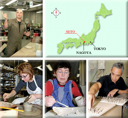
Seto is located in the hilly northern region of Aichi Prefecture, bordering Gifu Prefecture. In English, the name of Seto translate to "the place where the river runs quickly." However, while there is a river in Seto, it is not significantly large, nor quick-moving. Seto City is famous for its pottery and ceramics, so much so that the generic word for ceramics in Japanese is setomono. The main street along the river is lined with dozens of pottery shops. Every 3rd Saturday and Sunday in September, there is a very large pottery festival called Setomono Matsuri. This festival attracts about 20,000 visitors from around Japan and abroad every year.
Shizuoka

Shizuoka (静岡市 Shizuoka-shi) is the capital city of Shizuoka Prefecture, Japan, and the prefecture's second-largest city in terms of both population and area. It has been populated since prehistoric times. On the south-central Pacific coast Shizuoka has a humid subtropical climate (Köppen climate classification Cfa), which is hot and humid in the summers and rarely snows in winter.[6] Being closer to the warm Kuroshio current, Shizuoka is wet even by Japanese standards with only slightly less precipitation than Kanazawa on the opposite side of Honshu, but it is paradoxically the sunniest of Japan's major cities owing to the absence of summer fog and its sheltered location from the northwesterly winds off the Sea of Japan. Further north, however, the mountainous Ikawa area is part of the Japanese snow country, and there are ski areas.
Suwa

As of October 1, 2010, the city has an estimated population of 51,084 and a population density of 468.40 persons per km². The total area of the city is 109.06 km².
The city was founded on August 10, 1941, after the union of Kami-Suwa town, Toyoda village, and Shiga village. It is located on the shores of Lake Suwa.
The Suwa region is the leading industrial area of Nagano and was once known as "The Oriental Switzerland" in Japan for its highly developed precision machinery industry. Seiko Epson Corporation, a manufacturer of information-related equipment and Seiko timepieces, is headquartered in Suwa.
Suzuka

Suzuka is a city located in Mie Prefecture, Japan. As of November 2012, the city had an estimated population of 198,598 and a population density of 1020 persons per km². The total area was 194.67 km².Suzuka also boasts a significant industrial market, having major factories for both Sharp and Honda within its bounds. These companies outsource part of their labor to South American nationals in order to secure a contract-based workforce. Although the Japanese government is encouraging mandatory English-language education across the nation within Suzuka many courses offered, not only by private cram schools (juku) but also by publicly funded institutions, supporting Portuguese and Spanish. In a controversial move, the city's governing body, from April 2004, requires all garbage information and local signage to be displayed in both Japanese and Portuguese but not English.
Takabata
Takaoka

The climate of Takaoka is a a humid subtropical climate (Köppen climate classification Dfb), similar to that of much of the Japan Sea coast. All of the regions in Toyama Prefecture can experience large quantities of snow in winter. Depending on the year, the city can experience extraordinarily heavy snowfall, like, for example in 2006 when snow piled 1.4m high and in 2011 1.27m was recorded. From its border with Himi down to the southwest area of the city, a range of mountains stretch for roughly 150 m to 300 m with a particularly high stretch of mountains centering around Mt. Futagami near Himi. Shogawa River and the Oyabegawa River run through Takaoka and tributaries weave their way though the city center. Including small rivers, a total of 10 rivers flow through the city. The Amaharashi coast lies to the north of the region. Just off the coast lies the island Otokoiwa. Another island, Onnaiwa, lies nearby and the view of this island against the backdrop of the Mount Tate range of peaks is famous and features in promotional media for the region.
Takayama


Takayama is best known for its inhabitants' expertise in carpentry. It is believed carpenters from Takayama worked on the Imperial Palace in Kyoto and on many of the temples in Kyoto and Nara. The town and its culture, as they exist today, took shape at the end of the 16th century, when the Kanamori clan built Takayama Castle. About a hundred years later the city came under the rule of the Tokugawa shogunate. However, the high altitude and separation from other areas of Japan kept the area fairly isolated, allowing Takayama to develop its own culture over about a 300-year period. Located in the heart of the Japanese Alps, Takayama falls under a humid continental climate with some characteristics of humid subtropical climate. It features four distinct seasons with a wide range of temperature between the summer and winter, somewhat resembling parts of Northern Japan and Hokkaidō. Takayama is also part of the heavy snow area of Japan with snowfall most days throughout the winter season. Takayama along with many other cities and towns exposed to the Sea of Japan experience lake effect snow, generating some of the highest, most consistent snowfall in the world.
Toyama

The Toyama Plain is good farmland and historically it was a point of strategic and traffic importance. During the Feudal Age, it was frequently turned into a battlefield. Toward the end of the period of confusion, Sassa Narimasa became the governor of Etchū Province (the ancient name for present Toyama), and he accomplished the feat of taming the rampaging rivers, bringing about an even more flourishing agricultural industry in Toyama. In the early Edo Period, a positive industrial promotion policy was implemented on the production of medicine and washi (Japanese paper). Also, thanks to the improvement of both land and sea transportation routes, these industries thrived and Toyama became known nation-wide as the province of medicine.
Toyohashi

Toyota
 |
| Koran Valley |
Tsu
 |
| Tsu Castle from the air. |
Ueda
 |
| A sculpture at Utsukushigahara Open-air Museum in Ueda |
Yokkaichi

Yokkaichi is a manufacturing center that produces banko ware (a kind of porcelain), automobiles, cotton textiles,chemicals, tea, cement, and computer parts such as flash memory by Toshiba subsidiary Yokkaichi Toshiba Electronics. In Azuchi-Momoyama period, the port was developed and a regular market was open on 4, 14, 24 in each month. Thus, the city is named Yokkaichi because "yokkaichi" means "market on fourth day." In Edo period,Yokkaichi-juku was the forty-third station on the Tōkaidō.
Yokkaichi's port advanced remarkably during the Meiji period, primarily under the guidance of Inaba Sanuemon, a resident merchant interested increasing trade into Yokkaichi and the Ise area by modernizing the port facilities. Started in 1872, the project took 12 years to complete due to typhoons and difficulties in financing the project. This led to the port city being designated an Official International Port in 1899. The primary trade items shipped through Yokkaichi were originally seed oil, Banko ceramics, and Ise tea; but now it has developed into a port that now handles cotton, wool, glass, and heavy equipment.
The city was designated a 'modern city' on August 1, 1897. From 1960 to 1972, the city residents suffered health problems caused by the emission of SOx into the atmosphere from local oil chemical plants. InJapan, a disease called Yokkaichi zensoku (Yokkaichi Asthma) derives its name from the city, and it is considered one of the Four Big Pollution Diseases of Japan.
No comments:
Post a Comment